Monday, April 25, 2016

Tundra Tram – Up and Running


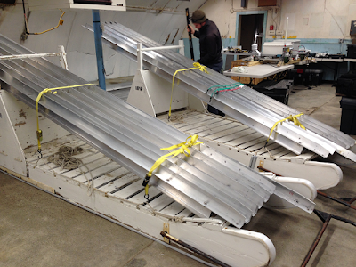
Field research for the NGEE Arctic team is off to an early start. There have been, and currently are, team members conducting snow surveys at our field sites on the Seward Peninsula. And there have been plenty of preparations for field studies on the North Slope as well. This week, Bryan Curtis (LBNL) and I travelled to Barrow for a number of activities; foremost among them was the reinstallation of the tram on the Barrow Environmental Observatory (BEO). We had disassembled the tram last fall and moved all the infrastructure and cart to storage facilities. This was done for several reasons, one being to remove the physical infrastructure from the field so that it did not pose a safety risk to local people who might traverse the BEO using snow machines during the winter. Another was to continue to upgrade the suite of sensors on the cart which required it to be shipped back to LBNL.

Our first task in Barrow was to transport all the uprights and supporting rails from storage to the field site several kilometers away. This was done by loading the materials onto wooden sleds and then transporting everything to the field using snow machines. Although much of the tram is constructed of aluminum, it is still heavy and required multiple trips to and from the field before everything was in place. It was cold with high winds in the afternoon. However, the weather cooperated and we had plenty of daylight for moving materials to the field.

When Bryan and I were not transporting materials to the field, the sensor cart was assembled and all components were tested including sensors, data logger, and control programs. This required several days of effort but no surprises due to careful planning by Bryan and others at LBNL.

Once everything was in the field it was just a matter of getting everything installed. The system was designed for ease of installation and thanks to the carefully planning by a number of people, including systems engineer Keith Lewin at Brookhaven National Laboratory, the uprights and raised rails were up, leveled, and ready for testing with only two days of effort.

The cart was the last thing to be transported to the field, and it too was easy to install. Once all the sensors had been connected the system was ready for testing. Everything worked perfectly! The cart made its maiden 2016 trip down the rails on April 20, collecting data every 0.5 meter along the 65-meter length of the tram.

Bryan will be keeping an eye on the system as he, and Sigrid Dengel (LBNL) now turn their attention to getting the eddy covariance system up and running. John Peterson and Emmanuel Legger, both from LBNL, will also be joining Bryan and Sigrid for a few days in order to reinstall the geophysics (ERT) array and take a few permafrost cores for physical characterization.

It was a great trip – thanks!


Tuesday, April 12, 2016

Erector Set...


Bob Busey, Cathy Wilson and Lily Cohen finished up the catchment-wide snow surveys on Friday and Saturday under mostly sunny skies and began preparation for our final task of the trip. The challenge was to construct two mobile snowmelt stations at the NGEE Teller site using the fewest, lightest, shortest, easiest to assemble, pieces of observation equipment, tower infrastructure, hardware and tools. It all needed to fit in the 5ft x 2ft x 2ft belly pod and back seat of a helicopter, and take a day and half to construct and test. Thanks to Bob Busey’s creativity and careful preparation in Fairbanks, we landed at the field site on Saturday with our artfully compact load and got to work building the stations.


One of the novel aspects of the station design was the use of survey tripods as the foundation of the infrastructure. These are easy to carry and set up in any terrain.  Bob designed to stations to mount on top of the tripods with unistrut and interlocking, lightweight aluminum poles. The snow sensor, temperature and relative humidity sensor, net radiometer, game cameras and data logger boxes were then mounted off of this simple scaffold.


While Bob and Lily constructed the tower infrastructure, I dug a pit in a snowdrift banked against a shrub thicket to install Bob’s new snow temperature profiler. The profiler has thermistors spaced every 4 centimeters along a wooden rod that has approximately the same thermal conductivity as snow. When inserted upright into the face of a pit, it continuously measures the temperature of snow from the ground surface up through the snow pack to the top of the ~90cm tall unit. We will use the instrument to assess changes in thermal conductivity in the snow pack as a function of depth and time during snowmelt. After installing and burying the profiler, and running its cables through a trench to the snowmelt station pit, I assisted Lily as she built the “yellow” snowmelt station in the shrub drift, while Bob completed the “blue” runoff observation snowmelt station overlooking the creek.


On Sunday we put the finishing touches on both stations and deployed two pressure transducers in the creek that was already flowing due to the unusually warm early spring temperatures. In fact, areas of shallower snow pack including the “blue” snowmelt station site were shrinking fast, leaving large patches of bare ground that had been snow covered two days earlier.


By Sunday afternoon we were packed up and ready to leave the site. Cathy got one more look at the two completed stations as she ferried the first load of empty action packers and tools back to Nome. She also spotted one of the first grizzlies of the season just a few miles North of the airport. Sunday night was spent reorganizing gear for the snow survey in Barrow this week, and snowmelt survey back at Teller next week.


Monday, April 11, 2016

Fair Weather...


We couldn’t ask for two more perfect days.  With brilliant warm sunny days we collected nearly a thousand snow depth measurements at intensive sites and along transects that cross the Teller NGEE watershed. As we climbed out of the site in the helicopter at 8pm, we could see the faint tracks of the tens of thousands of footsteps along remarkably straight survey lines that form the Teller snow grid. 


Every ten meters along kilometers of transects we collected snow depth measurements in order to quantify the spatial patterns of snow distribution in relation to vegetation type, slope, aspect, topography and elevation. For each transect Bob and Cathy set up a directional bearing using hand held gps, Lily Cohen (UAF) paced off distance using a three-meter-long avalanche probe, Cathy measured snow depth with a thaw probe and Bob Busey collected high resolution position data with the Trimble differential GPS rover.  


Given the depth and density of the snow pack we adjusted our snow density measurement goal from 40 sites to 10, and noticed that within just two warm days the snowpack had gotten significantly more “rotten” and wet.  In the mornings water in the snow pack froze into icy layers that were difficult to penetrate with the snowpack density tube, but by the afternoon the snow was so soft we struggled to stay upright, expending significant effort extracting ourselves from thigh deep postholes, even though we wore snowshoes or skis. On Saturday we will install two temporary mini-meteorology stations to track changes in the snow pack and radiation balance in anticipation of snowmelt, which will start soon if temperatures continue to stay warm.


Thursday, April 7, 2016

In Deep...


The trip was on. We received permission last week to land the helicopter at the NGEE Teller and Council sites for snow surveys and the helicopter and pilot were lined up, approved, and ready to fly. Bob Bolton, Bob Busey and I were greeted by our Nome logistics helper, Crystal Anderson-Booth, who helped gather and deliver the many action packers full of gear needed for our work. We spent Sunday organizing and testing equipment, including the new commercial SP2 digital snow hardness probe and Bob Busey’s prototype laser snow probe. We packed our survival bags with food for 3 days, sleeping bags, tents and other essentials that would be required if we were stranded in the field, a long shot.

On Monday morning we dropped our gear to be weighed and loaded on the helicopter, then waited until noon for freezing rain to clear so the helicopter could fly without danger of icing.  Using the great geopdf maps created by Lauren Charsley-Groffman and Garrett Altmann, we guided the pilot to the watershed and positioned ourselves at the first of 39 snow survey sites. We offloaded a belly pod and cabin full of gear, made another round trip for more gear, and then got to work. 


The first task on our list was to test out the new SP2 probe. Bob Bolton and I were having trouble getting it through an icy layer in the snowpack, so Bob Busey offered to show us how to use our “inner chi” to smoothly insert the probe. He described the process of centering oneself, then demonstrated the proper stance and with great ease inserted the probe to its maximum depth. Shortly after the probe completed its data cycle, he extracted it from the snow. We were quite impressed! Until I noticed the lower third of the probed was missing and thin broken wires that were hanging out of the end.  So much for Bob’s Chi, and the new SP2…


 …While Bob Busey skied off with the DGPS to survey snow surface elevation, Bob Bolton and I began the snow depth and snow water equivalent survey using standard instruments. With the first snow depth transect we knew we were IN  DEEP. Vladimir had reported a 20- 50cm snow pack at Pilgrim Hot Springs, but the snow depth at our first Teller site was 1.5m, which required shoulder deep (literally) pits (10 per site) for each of the snow density measurements. 


Luckily, our next two sites had somewhat shallower and less dense snow. We noticed that the snow was particularly light, loose and sugary in the shrub thickets within the channel. Unfortunately we only managed to complete 2.5 sites on our first afternoon in the field, far short of the 4 sites per half day that we expected to accomplish. 


Tuesday we woke to brilliant clear skis and were out at the field site by 9am. The plan was to work our way downhill across our survey grid. The pilot dropped me at the ridge with a load of equipment and as the helicopter took off to shuttle the Bobs to the top, I was stunned by the otherworldly beauty of the landscape and the perfect weather conditions. 


While Bob Busey set up the second GPS base station, Bob Bolton and I completed the suite of snow measurements at 2 more sites. As we made our way over to the third location we noticed a thin fog bank moving in our direction, and alerted the pilot in Nome of the change in the weather. Within the hour, the fog was upon us, and Bob Busey said it was time to leave the field because helicopters can’t land if they can’t see the ground. We didn’t want to get stranded, so we implemented our safety protocol which included a satellite tracker text message of our coordinates to the pilot, pilot confirmation that he was on his way, stowing non-essential gear in action packers to be left behind, collecting survival packs, turning on Cathy’s satellite telephone and hunkering down for the pilot’s arrival.

 Before long we heard the helicopter’s approach… then it was right overhead, but we couldn’t see it … then it flew off into the distance and was gone. At that point the second part of the safety plan kicked into gear. The pilot called to tell us where he landed and we set off to meet him at a new rendezvous point. As we moved off the ridge to meet the pilot, we were immersed in the increased complexity of working at a somewhat more remote field site than Barrow. But we were grateful to be well prepared for an emergency, and that Bob Busey was experienced in assessing the weather condition before it was too late to evacuate. Our caution made the difference between sleeping at the Dredge7 last night or being stuck in a cold tent on a hillside for 2 days. We woke up this morning to hot coffee and grounded aircraft due to freezing fog. It’s 4pm and still no take off or landing.