Monday, August 8, 2016

No Regrets…Well, Maybe One


The last three weeks have been a great time as more then 25 participants in the NGEE Arctic project conducted research at sites near Nome, AK. Everyone had a well-defined plan before coming to Alaska and executed those plans efficiently and safely. From my perspective this was a win-win situation.

One regret, however is that I did not get to work with the geophysics team from LBNL. This included John, Baptiste, Craig, Florian, and Emmanuel. I have worked with this group before both on the North Slope of Alaska and the Seward Peninsula. And it is a treat to say the least. They are a hard-working, talkative group of researchers who truly love their science and a good challenge.

This week that challenge was several ERT, seismic, EM, and GPR transects that easily totaled more than 5000 meters in length. The datasets that this team collected will be critical as we begin to characterize the subsurface environment of our sites, as well better understand the interactions between permafrost and bedrock and relationships to surface and groundwater hydrology. The hydrology aspects of this are being handled by Brent, Jeff, Cathy, Carli, Lauren, and Bob, colleagues at LANL and UAF. Together this is a strong team.

If you happened to be in Nome the past couple of weeks perhaps you saw their “geophysics” truck…it was easy to tell they were proud of their science!


Energy Balance of Tundra Landscapes


While the NGEE Arctic project has been interested in the energy balance of high-latitude ecosystems for several years, those measurements have focused on our site near Barrow, AK. We have used a suite of sensors to characterize energy-related processes across ice-wedge polygons and drained thaw lake basins. We have also deployed an instrument package on an automated cart that rides along a 65-m tram that collects data every three hours throughout the season. These systems are the product of our colleagues at LBNL and BNL.

This week Margaret, Bryan, Ori, and Sigrid – all from LBNL – were keen to deploy the portable system at sites near Council, AK on the Seward Peninsula. The suite of instruments included sensors for measuring short- and longwave radiation, incoming and reflected PAR, surface temperature, albedo, PRI, and NDVI. A camera could also be activated to take pictures of vegetation in each of the plots. The system was carried across the tundra and deployed at plots where we characterized community composition. This way we can interpret components of the energy balance and relate those to specific vegetation types. This will ensure that ecotypes are properly parameterized for use in our NGEE Arctic models.

Tasks were divided among the team; Ori prepared stakes for marking plots and she and Margaret picked representative 2.5 x 2.5 m plots along a transect and determined community composition. The transect crossed tussock tundra, several thermokarst features, and then two drained thaw lakes. Once plots were selected, Bryan and Sigrid walked from plot to plot with the sensors and made measurements as they went. A measurement would take 5 minutes with the greatest investment of time and energy spent walking between plots. We repeated measurements over a period of 4 to 5 days.  Ancillary data on thaw depth, soil temperature, and soil water content were also recorded at each plot. Our team had the opportunity to sample across a range of weather conditions; sunny days and rainy days.


It was a great week for deploying the energy balance system, looking at data, talking among our NGEE Arctic colleagues, and envisioning how we could improve the system in the coming months. Right now we are happy with the results and how they will inform models, especially models that explicitly represent vegetation dynamics including shrub expansion in tundra ecosystems.


Friday, August 5, 2016

International Collaboration...Meet and Greet on the Tundra


The NGEE Arctic project is keen to collaborate with scientific partners from around the world. This makes sense for any number of reasons, but especially as it relates to our ultimate goal of improving pan-Arctic simulations of ecosystem-climate feedbacks. We need to work closely with others to make this happen.

Scientists from the Arctic Research Center, Korea Polar Research Institute (KOPRI) have an active interest in the Arctic with research sites in Cambridge Bay, Canada; Zackenberg, Greenland; and Ny-Ă…lesund, Svalbard. Interestingly, they also have a research site on the Seward Peninsula not far from our field site near Council, AK. We have met with representatives of KOPRI in the past and prior to this field campaign had coordinated with them to share information and possibly conduct a few measurements at their site.

Yoo Kyung Lee and Youngwook Kim arrived at our site after a 2 hour drive from Nome and Margaret (LBNL) spoke briefly with them about conducting a geophysical transect near their field site, along with plot-scale measurements of energy balance and NDVI. Sebastien (LBNL) had flown his UAS equipped with an optical camera over the KOPRI site several days ago, so we already had (once processed) a high-resolution digital elevation map (DEM) for them.


Although we have just a few days left before everyone departs, we will be able to undertake the measurements in the next two days. Once completed, we can share the data and then discuss other ways in which we can collaborate in the future. We look forward to the interaction and welcome collaboration with other international partners!


Science Takes Flight on the Tundra


Every field trip to Alaska brings with it recognition that scientists working on the NGEE Arctic project are both curious and innovative. Curiosity is certainly one of the hallmarks of the scientific process. Innovation is also a distinguishing feature of science, especially in areas where emerging technology can be used to gain new insights into ecosystem dynamics.

This week Sebastien Biraud from Lawrence Berkeley National Laboratory joined us on the Seward Peninsula to acquire high-resolution aerial imagery of our field sites using an Unmanned Aerial System or UAS. Sebastien works primarily with the AmeriFlux program. In that capacity he has instrumented a quad-copter with an optical camera and with sensors that enable other properties of the landscape to be quickly and efficiently captured.

Sebastien kindly agreed to join us for this trip and has secured all the necessary FAA permits and approvals to fly his UAS in Alaska. These flights were intended to evaluate capabilities of the aerial platform and to preliminarily characterize several of our field sites. The quad-copter was surprisingly quiet and fast, taking a complete set of measurements for our site in less than 15 to 20 minutes. It passed overhead with nothing more than a “hum” as it went about collecting data.


Sebastien has agreed to give one of our monthly NGEE Arctic Science Talks and update the team on his results and thoughts on future collaboration. The data products derived from the UAS flights should be interesting and applicable to our goals and objectives as we characterize sites on the Seward Peninsula and “upscale” our field data to larger and larger areas. This will be important as we continue to represent insights gained from our field studies in Earth System Models.


Thursday, August 4, 2016

Trace Gas Emissions on the Tundra


Greenhouse gas emissions, including the flux of CO2 and CH4 from terrestrial ecosystems, provide an important land-atmosphere feedback to climate. As such, the NGEE Arctic project has several tasks that target a mechanistic understanding of the processes that control the carbon cycle. This applies not only to our field and laboratory studies, but also to our modeling where it is critical to properly represent the timing, rate, and magnitude of CO2 and CH4 flux from plants, soils, and ecosystems.

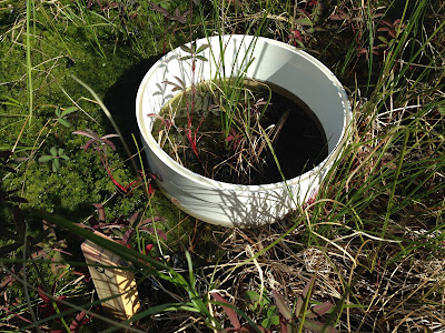
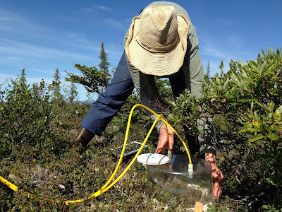
This week Ori (LBNL) and others are busy measuring trace gas flux at locations across the landscape at our field site near Council, AK. You may remember Ori from her work in Barrow where she has been helping with our measurements since 2014. Using similar techniques as those perfected at Barrow, Ori is working this week to deploy a network of chambers that will allow our team to determine how the flux of CO2 and CH4 varies in tussock tundra and in areas where permafrost thaw and thermokarst formation are underway. Ori has installed PVC bases into the soil at dozens of locations across the field site. She is using a portable gas analysis system from Los Gatos Research to measure flux rates by first placing a clear or opaque chamber on the PVC bases. An air-tight seal ensures that both the increase and decrease of CO2 and CH4 concentration can be measured, from which rates of ecosystem gas exchange can be estimated.


Field-scale measurements of CO2 and CH4 flux will be important for quantifying whether tundra ecosystems are a source or sink for carbon. More importantly these data, and the knowledge derived from them, will guide more mechanistic studies under controlled conditions in the laboratory and validate how those mechanisms are represented in models. The results that Ori and others gain this week will also help us prepare for more intensive measurements next year.


Monday, August 1, 2016

Digging Deeper


The NGEE Arctic project is interested in plant and soil processes. Not only does this include a focus on the biogeochemical mechanisms that lead to CO2 and CH4 emissions from tundra landscapes, but also on the structure and function of plant roots. Colleen (ORNL), who is one of our Phase 2 task leaders, understands the importance of roots and has made it a central theme for our research on the Seward Peninsula.

Today Colleen, Joanne, Verity, Eugenie, Holly, Mark, and Peter joined forces to collect soil cores and selectively excavate roots from several plants growing at our field site. Soil cores were taken using a battery-powered drill equipped with a specially-designed coring device. Using this technique Colleen was able to collect soil cores up to 35 cm in length in just a few minutes. Once cores were extracted from the barrel it was easy to see the different soil layers including green moss, organic-rich regions that contained most of the roots, and then mineral soil. These are placed in plastic bags, frozen, and shipped back to Colleen’s laboratory for analysis.


Verity, a post-doctoral research associate working on the project, also wanted to collect roots from plants in the field. This is a tedious process in which roots attached near the base of a specific plant had to be excavated and then traced out into the soil. In this way roots of various sizes and “root order” could be collected. Verity attacked this task with enthusiasm. It turned out that Peter was also particularly talented at tracing roots and helped Verity and Joanne collect a large number of roots. Although Peter has a background in field research, most of our colleagues know him for his work with Earth System Models. This week he traded high-performance super computers for helping us in the field; and apparently Peter enjoyed getting first-hand knowledge about how data on root structure and function were obtained for use in global climate models. We were glad to have him as part of the field team!